Across Europe and around the world, cultural and natural heritage sites face rising pressures from environmental change, urban development, natural hazards, illegal activities, and conflict. Satellite-based observations provide consistent, long-term information which helps authorities, researchers, and site managers understand how these sites are changing and where risks are emerging. Increasingly, space-based data are playing a crucial role in safeguarding them. Through Copernicus, free and open access Earth Observation data support monitoring, risk assessment, and evidence-based management decisions. In this Observer, we explore how Copernicus contributes to the long-term preservation and sustainable management of cultural and natural heritage.
Why cultural heritage needs Earth Observation
Cultural heritage sites include historic urban centres, monuments, archaeological sites, cultural landscapes shaped by centuries of human activity, and protected natural areas such as parks and coastal ecosystems. Many of these sites hold the status of UNESCO World Heritage Sites, recognised for their universal value. Yet recognition alone does not shield them from risk. Urban expansion can gradually encroach on defined buffer zones. Coastal erosion threatens historic ports and settlements. Ground motion can compromise the structural stability of monuments, while air pollution accelerates the degradation of building materials. Climate change intensifies flooding, drought and wildfires. At the same time, human activities such as looting, illegal excavations, deforestation, and waste dumping can damage sites directly or undermine their surrounding landscapes.
Monitoring these pressures requires accurate, consistent, and up-to-date information. Traditional field surveys remain indispensable, but they can be time-consuming, localised, and resource intensive. Earth Observation (EO) delivers a complementary perspective. By collecting satellite images consistently over many years and combining optical and radar data with atmospheric and land monitoring information, Copernicus enables authorities and researchers to compare past and present conditions and understand how landscapes and historic sites are evolving across regions and continents.
This integrated perspective helps identify emerging risks, track environmental change over time, and support evidence-based decision-making. Such capabilities are particularly relevant for the management and preservation of cultural and natural heritage sites, which increasingly depends on bringing together environmental, urban, and socio-economic information to inform coherent planning strategies.
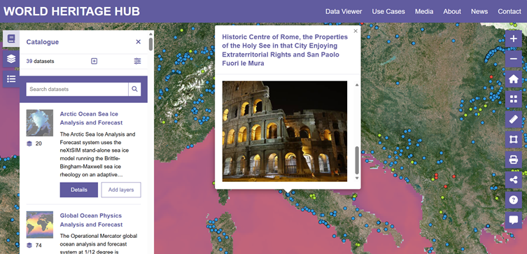
The Copernicus World Heritage Hub: a dedicated platform for monitoring and preservation
To support this growing need, the Copernicus World Heritage Hub serves as a centralised, web portal dedicated to heritage monitoring and preservation. The Hub acts as a central access point to Copernicus data products and services relevant to cultural and natural heritage, bringing together tools and datasets which might otherwise remain dispersed across different services.
The World Heritage Hub enables site managers, researchers, and decision-makers to use Copernicus data in a practical and accessible way. It supports evidence-based monitoring, conservation, and management of cultural and natural heritage sites.

The web portal features interactive tools and datasets from several Copernicus Services. Users can explore land cover and land use products, analyse ground motion information derived from radar imagery, assess coastal dynamics, and examine environmental indicators such as vegetation condition or soil moisture. By integrating multiple data streams, the Hub supports monitoring of both gradual and sudden change.
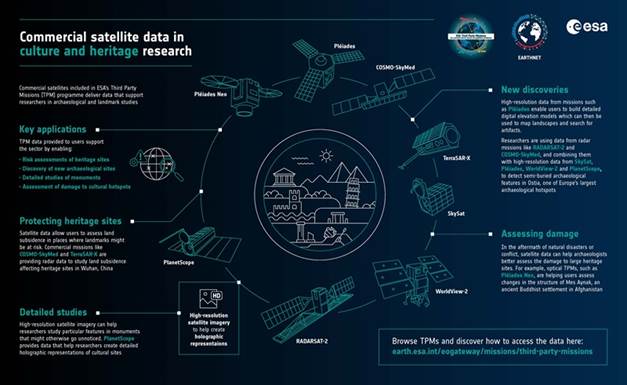
In archaeological contexts, subtle variations in vegetation patterns or soil moisture detected by satellite imagery can indicate the presence of buried structures. These signals can help guide field investigations and reduce the need for extensive exploratory excavation. In urban heritage settings, time-series data allow authorities to assess patterns of land use change around protected areas, identifying potential encroachment or infrastructure development in surrounding zones.
InSAR, a radar technique to measure displacement from satellite data, can detect millimetric ground deformation, providing early indications of subsidence or structural instability which may threaten historic buildings. Along coastlines, satellite data support the monitoring of erosion, sediment transport and sea-level impacts on vulnerable sites. Atmospheric information contributes to assessing air pollution exposure, which is particularly relevant for stone monuments and historic facades.
The World Heritage Hub also provides access to Copernicus information which is relevant in emergency contexts. Following natural disasters such as floods, earthquakes or wildfires, products from the Copernicus Emergency Management Service can deliver timely geospatial information to assess damage and support response planning. Beyond immediate response, the CEMS Risk and Recovery Mapping module also supports authorities by analysing hazards, vulnerabilities, and potential impacts before disasters occur. For example, multi-risk assessments have been carried out for archaeological sites such as Delphi and Ancient Olympia in Greece to inform civil protection planning. In areas affected by conflict, satellite monitoring may provide one of the few available means to document changes and potential damage.
How Copernicus contributes to cultural and natural heritage management
Beyond the World Heritage Hub, Copernicus contributes more broadly to the monitoring, assessment, and management of cultural and natural heritage sites. Satellite imagery can support the discovery of previously unknown sites by revealing patterns in vegetation or soil which could suggest underlying archaeological remains. At the same time, known sites can be mapped with high spatial resolution, providing updated inventories and detailed spatial context.
Time-series analysis allows researchers to observe seasonal variations and long-term environmental trends. For natural heritage sites, this may include tracking changes in vegetation cover, monitoring wetland extent or assessing drought impacts. For cultural landscapes, it can reveal shifts in agricultural practices, land abandonment or urbanisation patterns influencing heritage value and integrity.
Risk assessment is another key application. Products developed by the Copernicus Land Monitoring Service (CLMS) help evaluate urban sprawl and land use change in and around protected areas. Coastal monitoring, through Copernicus Marine Service and CLMS products, supports the identification of erosion hotspots, while atmospheric data inform assessments of pollution exposure. In this context, the Copernicus Climate Change Service (C3S) provides long-term climate analysis data and projections which help assess future risks such as increasing heat stress, changing precipitation patterns, and sea-level rise affecting historic coastal cities. The Copernicus Atmosphere Monitoring Service (CAMS) complements this by delivering information on air pollutants and aerosol transport, supporting analysis of how air quality and dust exposure contribute to the gradual degradation of monuments and historic materials.
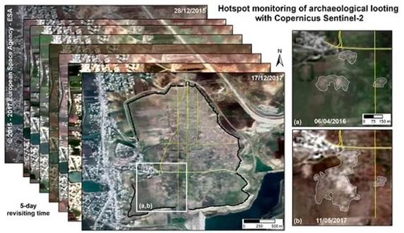
Beyond environmental pressures, the Copernicus Security Service (CSS) extends support to cultural heritage in security-related contexts. Through the Copernicus Service on Support to EU External and Security Actions (SESA), geospatial data can be generated to assess potential damage to heritage sites in areas affected by conflict, verifying reports of destruction, and identifying patterns consistent with looting or illicit excavation when on-the-ground access is limited.
Long term, systematic monitoring helps build resilience by identifying trends and supporting adaptive management strategies. In this way, Copernicus contributes not only to preservation, but also to the sustainable management of cultural and natural heritage sites in the face of climate pressures, urban expansion, and natural and human-caused hazards.
EUSPA’s role in enabling uptake across Europe and beyond
The European Union Agency for the Space Programme (EUSPA) supports the operational use of Coperncus data, including in the cultural heritage sector. By contributing to the implementation and uptake of the Copernicus Services, it supports the practical application of space-based information across sectors.
Through collaboration with EU institutions, Member States, non-governmental organisations, international organisations, and research centres, EUSPA supports the development and deployment of space-based tools tailored to heritage monitoring. Pilot projects, capacity-building initiatives and funding support help translate technical capabilities into operational services.
These efforts strengthen Europe’s ability to preserve its cultural legacy using advanced space technology, while also extending benefits beyond Europe to heritage sites worldwide.
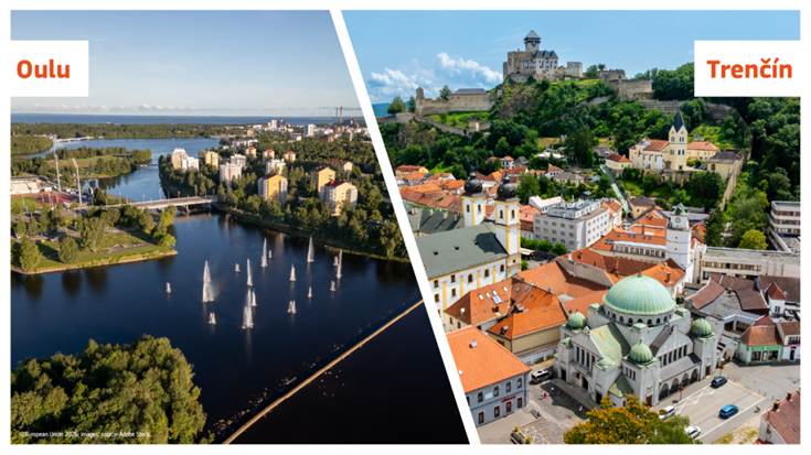
Cultural heritage in 2026: European Capitals of Culture
The European Capitals of Culture initiative, launched in 1985, highlights the richness and diversity of cultures in Europe and fosters a shared sense of belonging. It has also demonstrated how culture can contribute to urban regeneration, international visibility and sustainable development. In 2026, Oulu in Finland and Trenčín in Slovakia will hold the title.
Initiatives such as the European Capitals of Culture illustrate that heritage is not static. Historic cities continue to evolve, adapt, and grow. Managing this transformation requires balancing conservation with development. Copernicus data support urban planning, environmental monitoring, and sustainable tourism strategies in these dynamic contexts.
As cultural and natural heritage sites navigate the challenges of the twenty-first century, space-based information provides a reliable and consistent foundation for informed decision-making. By combining scientific rigour with open access, Copernicus helps ensure that the world’s cultural and natural legacy can be monitored, understood, and preserved for future generations.
Europa Monitor is a seasoned News Editor with over a decade of experience in journalism. Known for his editorial expertise and commitment to accuracy, Europa Monitor leads teams to deliver high-quality news content.