The European Commission has adopted a new Communication calling for a more integrated EU-wide approach to wildfire risk management, covering prevention, preparedness, response, and recovery. The strategy comes as the newly published Advance report on Forest Fires in Europe, Middle East and North Africa 2025 from the Copernicus Emergency Management Service (CEMS) confirms that 2025 was the most severe wildfire season on record for the EU, with over one million hectares burned—an area roughly equivalent to Cyprus. In this Observer, we look at the key findings of the report and the role of Copernicus in supporting wildfire monitoring and risk management across the continent.
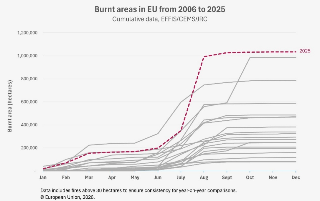
The 2025 fire season was the most severe ever documented in the EU, with a total of 1,079,538 hectares burnt across 25 EU Member States, nearly double the 2006-2024 annual average. According to the report, published annually by the European Forest Fires Information System (EFFIS), one of the early warning and monitoring components of the Copernicus Emergency Management Service (CEMS), the peak of the 2025 fire season occurred in August, when some of the largest fires of the year severely impacted Spain and Portugal.
Across Europe, the Middle East, and North Africa, the total burnt area reached 2.24 million hectares. Ukraine was the most affected country, accounting for nearly 30% of the total burnt area and 39% of all recorded fires.
Peak fire activity in the Mediterranean region
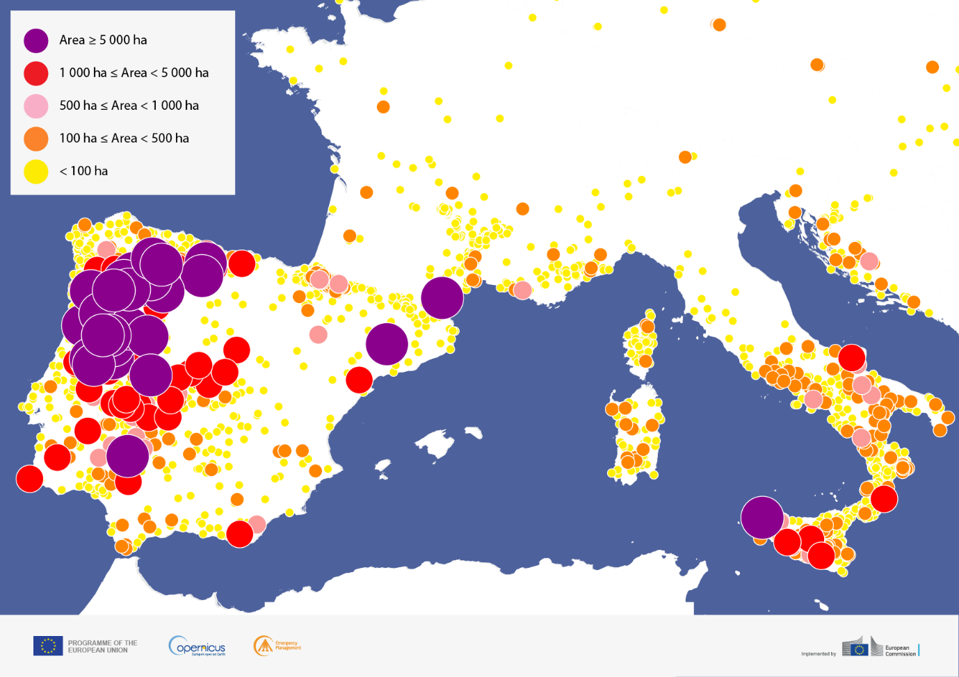
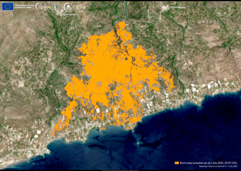
The western Mediterranean became the hotspot of fire activity in August 2025, as a series of almost simultaneous fires swept across the region. In just three weeks, fires consumed 561,322 hectares, accounting for more than half of the total burnt area recorded across EU Member States for the year.
The northwestern Iberian Peninsula was particularly affected, with 22 near-simultaneous fires, each exceeding 5,000 hectares and burning 460,585 hectares. From these fires,140,291 hectares were in Natura 2000 sites, the EU’s network of protected natural habitats, representing nearly a third of the total burnt area within these sites for the year.
Shifting patterns: wildfires spread beyond traditional areas
In a pattern consistent with recent years, wildfire activity started early in 2025, with seasonal peaks in the number of fires and burnt areas as early as March, when over 100,000 hectares burnt across the EU. The season then extended into summer, with multiple countries across the Mediterranean recording fires larger than 5,000 hectares in July and August.
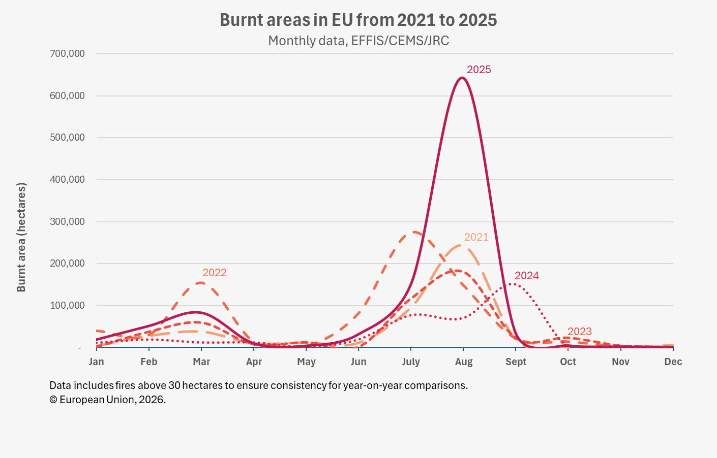
The 2025 fire season also confirmed two clear trends: wildfires are growing larger, and the frequency of megafires continues to increase. Wildfires are increasingly affecting higher latitude regions previously considered less prone to fires, such as Scandinavia and central and northwest Europe. Seven countries, Cyprus, Germany, Kosovo under UNSCR 1244, Slovakia, Spain, United Kingdom, and the Palestinian Territories, recorded their worst-ever fire seasons, while six others faced their second-worst on record.
Protected areas under pressure
A significant portion of the land that burnt across the EU in 2025, 424,023 hectares, was located within Natura 2000 sites, the highest figure ever recorded. This represents around 39% of the total burnt area in European countries, a proportion broadly consistent with previous years, reflecting the wider scale of the 2025 season rather than a disproportionate impact on protected habitats. Spain, Romania and Portugal accounted for two-thirds of the burnt area within these sites.
Beyond Natura 2000 sites, 19% of burnt land was agricultural and 25% was forested, including broadleaf, conifer, sclerophyllous (drought-resistant shrubland), and mixed forest types. The remaining 41% consisted of other types of natural land.
The EU response and the role of Copernicus
This report comes as the European Commission has recently adopted a new Communication calling for a more integrated EU-wide approach to wildfire management. The Communication builds on the Preparedness Union Strategy adopted on 26 March 2025, which identified wildfire risk management as one of its key priorities.
A centrepiece of this approach is EFFIS, a component of the Copernicus Emergency Management Service (CEMS). For over 25 years, EFFIS has provided geospatial services to emergency managers, supporting early warning as well as detection, mapping of wildfires, and the assessment of their impacts. Key actions proposed in the Communication include further improving the early warning and monitoring capabilities of EFFIS, as well as developing a Commission roadmap for regularly updated fuel maps, which show the distribution and condition of vegetation which may be affected by wildfires, across Europe.
The CEMS on-demand mapping service complements EFFIS by providing very high-resolution rapid assessments to support response and the recovery phase. The Communication also proposes the development of pan-European, standardised wildfire risk modelling within EFFIS, to support effective management strategies, best practices for risk reduction, and greater resilience in landscapes and at the wildland–urban interface, or the boundary between populated areas and undeveloped vegetation.
Europa Monitor is a seasoned News Editor with over a decade of experience in journalism. Known for his editorial expertise and commitment to accuracy, Europa Monitor leads teams to deliver high-quality news content.